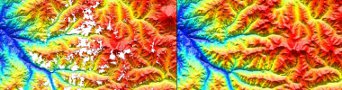
 Interpretation of Landsat and ASTER data, grid merging and mosaicing, Principle Component Analysis and image processing, Structural Interpretation, Clay ratio and Iron oxide image processing, SRTM re-gridding to remove nulls and artifacts.
 Rapid is a geophysical
  Acquisition Project Management for Ground, Marine and Airborne magnetics and gradient surveys. Processing of Magnetic data, grid merging and mosaicing. Fourier derivative generation, inversion and interpretation.
 Acquisition Project Management for Ground, Marine and Airborne gravity and gradiometry surveys. Processing of Gravity data, grid merging and mosaicing. Fourier derivative generation, inversion and interpretation.
 Acquisition Project Management of 2D, 3D and Borehole surveys. Processing of Resistivity & IP data, pseudo-section generation, inversion and interpretation.
 Acquisition Project Management for Ground and Airborne Radiometric surveys. Processing of Radiometric data, grid merging and mosaicing, grid ratio and derivative generation. Radiometric Principle Component Analysis and image processing, Structural Interpretation and anomaly picking, ranking and drill hole planning.
 0
0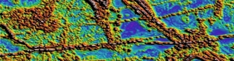 1
1 2
2 3
3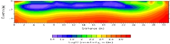 4
4 5
5Satellite Geophysical Services, Imaging and Quality Control:
Interpretation:
- Landsat and ASTER data grid merging and mosaicing
- Landsat and ASTER Principle Component Analysis and image processing
- Landsat and ASTER data Structural Interpretation
- Landsat and ASTER data Clay ratio and Iron oxide image processing
- SRTM re-gridding to remove nulls and artifacts
GGMPlus:
- Generation of DG/GA derivative products
- Generation of Bouguer anomaly derivative products
- Generation of Residual derivative products
